 |
| NAZARETH. |
| Page 316. |
|
[Table of Contents] [Previous] [Next] |
J. W. McGarvey Lands of the Bible (1881) |
C H A P T E R V I I.
PLACES IN GALILEE.
§ I.
NAZARETH AND ITS VICINITY.
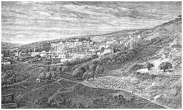
ALTHOUGH Nazareth was once an insignificant village, out of which no good thing could be expected to come,1 and although it has continued until a comparatively recent date in much the same condition, it is now the largest, the handsomest, and by far the most important town in all Galilee. It is nearly midway between the Bay of A'cre and the southern end of the Lake of Galilee, but not on a thoroughfare. It lies two or three miles south of the principal route of travel across the mountains of Galilee from sea to lake, and it is about two miles north of the Plain of Esdra'elon, from which it is reached by ascending a cliff 1000 feet high, so steep that horses can climb it only by severe toil. It is so nestled among surrounding mountains that it is approached by all of its principal roads down steep hills. It lies on the northwestern side of a wâd'y, and extends from the bed of the wâd'y about half-way up the slope. The top of the ridge is about 300 feet perpendicular above it. Its length up and down the wâd'y from northeast to southwest is about half a mile, and its width a quarter of a mile. It is well built of stone, and its houses have usually a fresh appearance; many of them, indeed, are new, and the white limestone of which they are built is unstained by the weather. Near [313] the northeastern end of the town, under the floor of the Greek church, is the spring on which the inhabitants are chiefly dependent for water. By an opening through the stone floor, under an altar, water is drawn in a little silver bucket. Here, according to the Greeks, while the Virgin Mary was at the spring to get water, the angel Gabriel appeared to her and announced the birth of her Son. It is called the Virgin's Fountain, and the church built over it is called the "Church of the Annunciation." A picture of Mary and the angel hangs over the altar. An underground conduit leads the water of the spring about 100 yards south from the church, where it gushes out in two streams through the southern wall of a little stone building in which the conduit terminates. The streams issue from two stone spouts, about eight feet apart and about three feet from the ground. The roof of the little building and its side-walls project three or four feet on this side, so as to afford a shelter against rain and sun to the women as they fill their water-jars at the spouts. Here a crowd of women may be seen all day long, laughing, chatting, quarreling, pushing for a place at the spouts, and coming and going. This affords the best opportunity to see the women of the laboring class, and it has been truly remarked by nearly all travelers, that the women of Nazareth are handsomer and more tastefully dressed than the laboring women of any of the more southern towns of Palestine. They show, however, a different conception of modesty in regard to the exposure of their breasts than is common in America. In this they are not peculiar among the women of Palestine, but their more pleasing appearance in other particulars causes this fault to be more marked.
At the opposite or southwestern end of the town there is a large and well-built Latin church and convent. Within the former a flight of stone steps leads into an artificial cavern under the large altar, which is called Mary's Kitchen; and here, according to the Latin monks, is the real place at which Gabriel appeared to Mary. The man who can believe either the Greeks or the Latins in regard to this matter is blessed with an easy credulity. But even the credulity of such a person must be taxed when he is led by a Greek priest to an old room in a dwelling-house in another part of the town, and told that this is Joseph's carpenter-shop; and when still another priest leads him into an old building and shows him a rock in its natural position, about 3 feet high and 10 by 5 feet on top, saying that this is the dining-table used by Jesus and the twelve!
It is pleasant to turn away from these blind attempts to identify the locality of incidents in regard to which we have no clue in the [314] Scriptures, and to find the unmistakable spot where occurred the most startling incident recorded in the history of Nazareth,--the attempt of its people to cast Jesus down the brow of the hill on which their town was situated. In the upper edge of the town, near its northeastern end, there is a perpendicular precipice about 60 feet high, made by the falling in of the roof of a large cavern, which once ran along the face of the ridge for a considerable distance, and much of which still remains. Had this precipice been already formed in the time of Jesus, it might be taken as the place of precipitation, but the rock appears to have been exposed but a comparatively short time. Near the other extremity of the town, however, and at about the same level on the hillside, is a natural precipice about 40 feet high, and evidently of ancient origin. A few houses now stand above it, and on the level platform of rock at its base stands a Maronite2 chapel. Here, in the imperishable rock, unchanged by human hands, is the spot where this tragic event occurred, answering in every particular to the words, "They thrust him out of the city, and led him to the brow of the hill whereon their city was built, that they might cast him down headlong."3 True, the spot is now within the limits of the city, but it is obvious at a glance that all the houses near the precipice are of modern construction. Conder thinks that the ancient town stood higher up the hill than the modern city, but this is immaterial, and is doubted by some competent judges.4
The present town of Nazareth is largely of recent growth. Conder remarks: "Twenty years ago Nazareth was a poor village; now it is a flourishing town."5 It has probably doubled its size and population within that period, and many new houses were in course of erection when the author was there in 1879. This prosperity is due to the use of European capital and influence. The present Greek church, as well as that of the Latins, and a very handsome chapel of the English church, are among the recently-erected public buildings, while the most imposing structure about the entire city, a large and handsomely-built orphanage, perched on a bench of the hill high above the entire city, was founded in 1872, and is large enough to accommodate 200 girls with lodging and school-rooms. Orphan girls of native families [315] are received into it, provided for, and educated. It belongs to the English "Society for Female Education in the East." About 40 girls were enjoying its privileges in 1879, and the children of European residents in the city also attended the school as day pupils. Its work must prove of incalculable value to the people of that country. Another conspicuous and most important structure is the hospital and dispensary, established by a society in Edinburgh as a medical mission, and now under the control of Dr. Vartan (see page 47). In no respect are the natives of the country more destitute than in medical treatment, and it is undoubtedly wise to make the medical treatment of the body, which they universally accept with joy, the avenue of approach to the spiritual healing of the soul. Our picture of Nazareth was taken at too early a period to show the more recent of these improvements; it is therefore quite an imperfect representation of the town at the present time, and, like nearly all engravings made from photographs, it fails to adequately represent the height of the hills. An account of Nazareth is incomplete without a description of the view which is obtained from the summit of the ridge, on whose southeastern slope it is situated. There can be no doubt that Jesus often stood on this lofty eminence, now crowned by a very old Mohammedan wel'y, and enjoyed the far-reaching prospect.
Standing here, the city lies at your feet, and you realize the barrenness of the hills immediately about it. A spot with soil so poor and thin is seen nowhere else in Galilee, nor in any part of the country north of the Desert of Judah, near the Dead Sea. This alone must have made Nazareth an insignificant place before European capital improved it. It shows that in selecting a home for Jesus on earth his Father chose not only a place apart from trade and travel, a place whose inhabitants were of bad repute, but one whose poverty of soil naturally led to poverty of morals and intelligence.
But when the eye is lifted from the basin of surrounding hills in which Nazareth is hid, it stretches in every direction over a magnificent prospect. Back in the direction whence we have traveled, much of the Plain of Esdra'elon is in full view, with Mount Gil'boa and Jebel Dû'hy on the left, and both Nain and Endor visible on the northern slope of the latter. To the right the long ridge of Mount Carmel is distinctly seen from end to end, and farther to the right are the Plain and the Bay of A'cre. Turning toward the north, all Galilee stretches before us, the lower hills dotted with many villages in the foreground, and the loftier mountains rising toward the Lebanon range in the distance. To the northeast are the hills which hang over the [316]
|
| NAZARETH. |
| Page 316. |
western shore of the Lake of Galilee, and towering above all in the dim distance is the snow-capped and rounded summit of Mount Hermon. Immediately to the east the circle is completed by the conical top of Mount Tabor.
When Jesus departed from Nazareth to dwell in Capernaum, his path led from the northern end of the town to the white limestone cliff which terminates the valley in that direction, and then, making a right angle to the left, ascended a bench cut along the face of the cliff to the top of the ridge. After crossing the crest of the ridge it descends toward the northeast. As he ascended the cliff, with his left side toward the town, he obtained the last view of his childhood home, from which he was being driven in fierce hatred by men who had been his neighbors and friends from his boyhood,--men to whom he had often read the Scriptures in the synagogue while he was an unpretending carpenter. If he wept over Jerusalem when approaching it for the last time, what must have been his emotion when, under circumstances so painful, he looked for the last time upon the humble village where for thirty years he had spent a quiet and peaceful life! But his singular biographers have left a veil hanging over this parting scene, and we may not lift it except in imagination. We leave Nazareth as the traveler usually leaves it, by climbing the same rocky path, and giving it the same farewell glance over the left shoulder as we cross the crest of the ridge.
Although Galilee was anciently full of large towns,6 as it now is of villages, scarcely any of them has a name in the Bible, except those immediately about the Lake of Galilee and the headwaters of the Jordan. The only one in the vicinity of Nazareth that has been saved from this obscurity lies on the road toward the lake, about three miles from the city. It is now called Kefr Ken'na (the village of Cana), and is usually regarded as "Cana of Galilee." It is situated on the westward slope of a hill, with a copious and unfailing spring adjoining it on the southwest. An old one-story house near the lower edge of the village is regarded by the Greeks as the one in which the wedding-feast was held when the water was turned into wine.7 The room is a rude chapel, and at one side stand two old stone mortars, one holding about eight gallons and the other about ten, now used for [317] immersing infants, but said by the attending priest to be two of the identical water-pots of stone that held the water out of which the wine was made. Just above this building, and separated from it by a narrow street, is a new chapel belonging to the Latins, surrounded by a stone wall seven or eight feet high. It is built on the ruins of an ancient church, part of the wall of which is left standing in the rear of the chapel, while some of its granite columns and drafted stones lie scattered about the yard in front of the chapel.
Kenna is 22 miles, according to Conder, from Bethab'ara, where Jesus left John the Baptist the third day before the marriage at Cana; it is about twelve miles from Tiberias; and from Capernaum, where the second miracle which he wrought in Cana took effect on the son of a nobleman, it is distant 18 or 20 miles.8 This, one of the earliest of the miracles, was wrought at a greater distance from its subject than any other on record.
There is another village 12 miles north of Nazareth called Ka'na el Jilil, Cana of Galilee, which some have supposed to be the Cana of John's Gospel,9 but, though it has the advantage in name, it does not correspond so well in distance from Bethab'ara and Nazareth, and the preference appears to be correctly given to Kefr Ken'na.
On the way from Kefr Ken'na to Tiberias, and about five miles from the former and four from the latter, is an isolated hill whose top divides into two peaks, called by the Ar'abs Karn Hattin'. It has been held by a tradition which dates from the crusading period as the spot on which the Sermon on the Mount was delivered, and for this reason it is called the Mount of Beatitudes. Its two peaks are commonly spoken of by writers of travel as the Horns of Hattin'. But the sides of the hill are too steep for the assembling of such a multitude as heard the Sermon on the Mount, and its summits are not sufficiently capacious. There is no reason at all for giving credence to the tradition. At the foot of this hill, to the southeast, is an uneven plain, somewhat more than a mile in extent each way, which is a noted battle-field. Here, on the 5th of July, 1187, the Saracen leader, Saladin, gained a decisive victory over the Crusaders, which gave the death-blow to their power in Palestine. Many prisoners were taken, of whom a large number were sold as slaves, and others butchered in a spirit of revenge.10 [318]
§ II.
ABOUT THE LAKE OF GALILEE.
Passing on eastward four miles from this fatal field, we reach the brow of the hill overlooking Tiberias, on the southwestern shore of the Lake of Galilee. A gradual descent over a rocky path brings us first to the cemetery which lies west of the town, and then continuing due east we pass through the western gate of the dilapidated wall, and find ourselves near the ruins of a castle on the left which defended the northwestern angle of the city. The modern city is on lower ground to our right. We are in the midst of an open space of two or three acres between the castle and the compact mass of houses which make up the town, and we are at such an elevation as to overlook the tops of the houses, being 50 feet above the surface on which they stand. The town is about half a mile in length along the lake-shore, and a quarter of a mile in width. Just opposite where we stand is a small gateway through the eastern wall, opening into the shallow water of the lake; for all of the wall on the east is washed by the waves of the lake on the outside. To the left of our position, about midway the northern wall, much of which is thrown down, is the northern gate. The southern gate is about midway the southern wall, and is reached from our position by passing through the town along a crooked and narrow street which is the principal thoroughfare. Thus the town is surrounded by a wall with four gates on the four sides of the quadrangle, and it is strengthened by strongly-built round towers, one of which stands at every corner, and one midway the wall on every side. The wall is greatly shattered in many places, and prostrate in some, while the large and massive castle above mentioned is in ruins. This wreck was effected by a fearful earthquake which visited this region on January 1, 1837. It not only ruined the walls, but it threw down most of the dwellings in the city and killed about one-half of the population. The walls, where they are entire, are about 20 feet high and 6 or 8 feet thick. They are built, as is the chief part of the town, of basalt, and consequently, except where plaster and whitewash hide the blackness of this rock, the town has a very sombre and altogether unattractive appearance.
The present population of Tiberias is estimated at 3000 (Baedeker), whom more than half are Jews, and the majority of the others Greek and Roman Catholics. The Roman Catholics have a chapel [319] and monastery in the town, while the Jews have a number of small synagogues. There is also a dilapidated mosque for the Mohammedan population, and, though the building is almost a ruin, its minaret is the most beautiful and graceful in Palestine: it is hexagonal, and built of yellowish limestone, with bands of black basalt at short intervals.
Of all the towns and villages which stood on the shores of the Lake of Galilee in the time of Jesus, Tiberias alone remains. Jesus appears never to have entered this town. It was the only one which was not exalted to heaven by his presence and his teaching, and it is the only one which has not been brought down to hades for refusing to repent at his bidding. It was founded by Herod Antipas, the tetrarch of Galilee, by whom John the Baptist was beheaded and Jesus mocked, and it was named in honor of the Emperor Tiberius.11 It is now called by the more euphonious name of Taberî'yeh. It was doubtless on account of its being the residence of Herod that Jesus never visited it. Herod was the one man on earth to whom Jesus would not speak.12
After the destruction of Jerusalem by Titus, Tiberias became the residence of the few Jews who were allowed to remain in Palestine. In the second century it became a noted seat of Hebrew learning, and continued to be so for nearly 200 years. Here the traditions of the elders, which had been transmitted before for many generations orally, were committed to writing in the form now known as the Mishnah by Judah Hak-Kadôsh. The date of this work is variously stated from A. D. 190 to A. D. 220. Here, also, about the middle of the second century, the Jerusalem Talmud was compiled, and here the work of the Masoretic critics was commenced. The celebrated Jewish writer of the twelfth century, Maimon'ides, also lived and died here, and his tomb is still pointed out in the old unfenced graveyard west of the town. The town figured prominently in the wars of the Crusades, and has often been taken and retaken by contending armies. Its present wall was built about the middle of the eighteenth century.
South of Tiberias the rocky shore of the lake is covered with continuous ruins over a space a mile in length, and varying from 200 to 300 yards in width. It is evident that the city once extended over this space, and that it was then a much larger city than at present. The character of the ruins indicates also a city of more important buildings than any within the walls of the present town. At the southern limit of these ruins, about a mile from Tiberias, are the [320] celebrated mineral hot springs. They break out from the base of the mountain, which here approaches within about 100 yards of the water's edge, and are led into several bathing-houses, where circular stone tanks are kept constantly full of the hot water, and invalids afflicted with various diseases are constantly bathing and almost cooking themselves. The temperature of the water is 137°, and it has to be reduced a little before the bathers can venture into it at all. The water contains some salt and small quantities of sulphur and iron, but the author has seen no reliable analysis of it. People from all parts of Palestine resort to the baths, and some of them live in tents pitched near the lake-shore while daily using them.
At the extreme southern end of the lake are the ruins of the ancient town of Tarichea, mentioned in Josephus,13 but not mentioned in the Bible. It covers the crest of a ridge about 50 feet high, which rises from the edge of the water about midway the southern shore of the lake and slopes downward toward its eastern and its western end. The Jordan, which leaves the southeastern point of the lake at almost a right angle and runs a little north of west about a mile, passes along the southern base of this ridge, and thus it is almost surrounded by water. A short distance to the southeast, across the Jordan, is the village of Semakh'.
The places on the western shore of the lake above Tiberias are those which most interest the reader of the New Testament. The lake itself and its general surroundings we have briefly described in Part First, Chapter I., §. VII. A ride of a little more than two miles, northwest, along a narrow beach between the mountains and the water's edge, brings us to the land of Gennesaret, so often mentioned in the Gospels. It is a recess in the hills, which suddenly retire from the lake-shore, leaving a smooth and level plain three miles long at the shore, and two miles wide at the widest place. The village of Mejdel, which is nothing more than a collection of half a dozen rude huts, stands close to the lake at the southeastern corner of this plain. It represents in name and locality the ancient Magdala, the home of that Mary who, from this name, was called Mary Magdale'-ne. The mountains, which bound the plain on the south, run west from Magdala about a mile, and they stand in an almost perpendicular wall. At the southwest curve of the plain there comes down into it from the highlands a deep, narrow gorge called Wâd'y Hamâm', with a small stream of water flowing along its narrow bed of rock. On the east side of this wâd'y [321] and the south side of the plain rises a perpendicular precipice 1150 feet high, on whose side, nearly 1000 feet from the ground, are a large number of artificial caverns, utterly inaccessible without the use of ladders and ropes. These caves, which have interior connections with one another, and space for about 600 men, were occupied in the time of Herod the Great by robbers, who dwelt here with their wives and children and committed fearful depredations on the surrounding country. Herod, after defeating them in a battle in the open field, followed the remnant to their hiding-place and undertook to capture them. Finding it impossible to attack them by the narrow paths and movable ladders by which they reached their caves, he adopted the hazardous expedient of letting down some of his most valiant soldiers from the top of the cliff to the mouths of the caves in boxes suspended by chains. Thus he succeeded in slaying all the robbers.14 The same caverns were afterward occupied by monks and hermits, and they are interesting relics of ancient barbarism and superstition.
The lake-shore, along the whole length of the plain, is a smooth, sandy beach, and the water is shallow for a considerable distance out. The level of the plain, along which the road runs, is about 10 feet above the level of the lake. The surrounding hills make a kind of amphitheatre, and the plain, which has a luxuriant soil, well watered by several small streams from springs in the hills to the west, is covered with a dense growth of weeds and brushwood, except a few acres which are cultivated in grain.
The northern end of the Plain of Gennesaret is bounded by a perpendicular cliff of rock, which projects from the hills into the water of the lake and drops down with a perpendicular descent of 150 feet into the water. This is the only point in the entire circuit of the lake at which there is no passway between the hills and the water. Under the southern base of this cliff there bursts forth a large stream of water, which runs along the base of the cliff about 100 yards and empties into the lake. It is from 30 to 40 feet in width and from 2 to 3 feet deep, with a slow current. The water is pure and refreshing, but not cold. To the left of the fountain, and on higher ground, there is a ruined khân, not very ancient, and other ruins of greater antiquity lie scattered about over a considerable area. The entire place bears the name Khân Min'yeh, and it was taken by some of the earlier explorers, led by Robinson, for Capernaum, but for conclusive reasons that identification is now abandoned. [322]
The road, in crossing the promontory of Khân Min'yeh, first ascends the elevation on which the ruined khân stands, then turns toward the lake and climbs the side of the cliff, and after reaching an elevation of 70 or 80 feet it passes along a kind of trough four feet wide cut in a narrow shelf of the rock, with the perpendicular cliff on the left and a parapet left in the natural rock on the right. This last acts as a balustrade to guard man and horse from falling over the precipice into the lake.
After crossing this promontory we descend into another plain about a mile in extent along the lake-shore, and the same in width back to the gradually-sloping hills which bound it on the west. At the northern limit of this plain, where the hills come out close to the shore, but not so close as to prevent easy passage, is another copious fountain, one of the most copious in Palestine. It bursts forth from under the hill a short distance left of the road, and first fills a reservoir constructed of heavy masonry. Thence it flows forth in several streams, one of which runs toward the lake and propels a mill just at the lake-shore which has two water-wheels and two pairs of millstones. One of the other streams is led off in an irrigating channel into the plain, and the others run to waste, making their way into the lake south of the mills. The ruins of two mills now disused stand near by. This spring is called by the Ar'abs Ain et Tabig'ha, but it is not mentioned in the Scriptures.
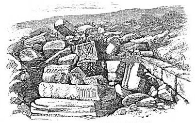
After passing the narrow headland which closes up the last-mentioned plain, another opens to the left and extends, with varying width, from this point entirely around the northern end of the lake. About a mile and a half from the point at which we enter this plain we reach the ruins called Tell Hûm, which alone answer in every particular to Capernaum. They cover a space about half a mile in length along the shore, and a quarter of a mile in width. The ruins consist chiefly of confused heaps of basalt building-stones lying where the walls of the houses stood. They are weather-worn on their exposed parts to an extent which indicates a long period of exposure. Near the shore are several structures whose walls are still standing from 6 to 10 feet above ground, and in the midst of the thickest portion of the ruins, about 100 yards from the shore, are the well-preserved foundation-walls of a building, 57 by 75 feet, which has been pronounced by competent judges of ancient architecture the ruin of a synagogue. It fronts to the south, and it had three doors in that end, corresponding to the three divisions of the interior made by two rows of columns which supported the roof. The pedestals of some of these columns are still seen, and broken [323] pieces of the columns lie scattered about. One of the pedestals presents on its top the shape of a heart, and the column which stood upon it must have had the same shape. Slabs covered with rich carving, once the ornamental lintels over doors and windows, lie scattered about the ruin. It was an elaborate and costly structure, and the material of which it was built is a fine-grained limestone almost as smooth as marble. It must have been quarried at a considerable distance from Capernaum and brought thither at heavy expense, for the rock of the vicinity is all basalt. This ruin was first discovered by Robinson, who pronounced it the remains of a Jewish synagogue, and so it has been regarded by more recent explorers.15 We know that the centurion whose servant was restored to health by Jesus in Capernaum loved the Jewish people and built for them a synagogue,16 and it is a pleasant thought, not devoid of probability, that here are its ruins. Such an object transports the traveler into the very midst of the scenes of the Saviour's life and labors. The following cut represents a portion of the ruin.
 |
| RUINS OF A SYNAGOGUE: CAPERNAUM. |
Capernaum enjoyed a far more eligible situation than any other town which ever stood on the shore of this lake. The site projects a short distance into the lake, with the shores receding so as to form a shallow bay on either side. A smooth and gradual slope stretches back to hills of moderate elevation, which are covered with a rich soil and are tillable to their summits. The front is toward the southeast, and almost the entire lake, with its surrounding hills, is in view, while every [324] breeze that blows from land or water sweeps freely over it, and the waves are forever breaking on the blocks of basalt that line the shore. But Capernaum can never have presented an attractive appearance, on account of the black rock of which all its houses except the white
 |
| SITE OF CAPERNAUM. |
synagogue were built. Jesus chose it as a home not for its beauty, but for the sake of its simple-hearted people.
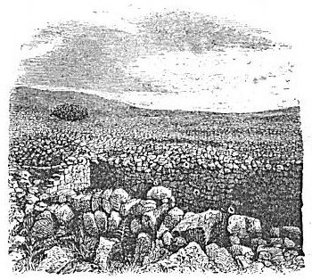
Two miles and a half north of Tell Hûm, on the east side of a wâd'y which comes down from higher hills beyond, are the ruins of Keraz'eh, the Chorazin of the Gospels. They consist of confused heaps of stone, as represented in our cut on the next page, beneath which are traceable [325] the foundations of dwelling-houses, and in the midst of these the remains of one synagogue. All were built of basalt. Captain Wilson here traced the foundations of dwellings, and found them usually square
 |
| RUINS OF CHORAZIN. |
and of different sizes, the largest measuring about 30 feet.17 The wall was about two feet thick. There was a low door in the middle of one of the walls, and the windows were small openings about a foot high and six inches wide. One or more columns of stone in the interior supported the flat roof. The houses of the largest size were divided into four rooms. Such were doubtless the dwellings of the people of Galilee in the time of our Saviour, and in such dwellings he habitually found lodging.
A curve of the shore inland northeast of Capernaum forms a shallow bay, whose shore-line is about a mile in circuit. On a projecting point, which might be called a cape, separating this bay from another farther north, are the basaltic ruins of an ancient village whose site answers well to that of Bethsaida. Some explorers have located this town at Khân Min'yeh (Baedeker, 373), and others on the western bank of the Jordan near its mouth (Thomson, ii. 9), but the Scripture allusions show clearly that it was close in the vicinity of Capernaum, and both of these sites are too far away.18 In the bay just [326] above this ruin the boat in which the author's party were sailing when a severe storm broke upon them found shelter about sunset, and lay at anchor safe from the western wind. This shows that it is a favorable place for the landing of fishing-boats such as were used by Peter and Andrew and the sons of Zebedee.
From the spot which we identify as Bethsaida, around the head of the lake to the mouth of the upper Jordan, is about two miles, the path leading along a plain between the hills and the water, which varies in width from 50 to 200 yards and is adorned with many clumps of oleanders. These bushes, indeed, abound on every side of the lake. The river, where it enters the lake, is obstructed by its own deposit, which extends out into the lake a considerable distance, making shallow water and a muddy bottom. But the fresh food for fish constantly washed in by the Jordan causes the fish of the lake to congregate here, and consequently in this vicinity nearly all of the fishing is now done. So must it ever have been, for the same reason. Under the shade of a solitary tree on the beach, at the nearest landing-place west of the Jordan's mouth, the author and his party took their noonday lunch, and they believed that they were eating near to the spot where Jesus fed the seven on a memorable occasion. It is highly probable that this is also the spot at which Jesus called the four fishermen, Simon, Andrew, James, and John, for it is not far from their home at Bethsaida, and it is the very part of the lake in which they would be likely to spend the night in fishing.19
East of the Jordan, at its entrance into the lake, there is a plain called Butî'ha, whose shore-line curves around the northeastern part of the lake about four miles, while its width, from the shore back to the hills, is somewhat more than a mile. The plain is larger than that of Gennesaret, but much like it in shape and surface. It is traversed by three streams from the hills, and much of it is too wet for cultivation; but it produces grain, cucumbers, and melons, and is cultivated by the same tribe of tent-living Arabs who occupy all the Jordan Valley,--the Ghuwâr'ineh. On the east bank of the Jordan, and at the foot of the hills which bound the plain in that direction, are the ruins of Bethsaida Julias, the Bethsaida near which Jesus healed the blind man, as recorded in Mark vii. 13-27. It was enlarged by Philip the tetrarch, and called by him Julias, in honor of Cæsar's daughter. Here Philip died and was buried in a tomb previously built by [327] himself.20 The present ruins are of unhewn basaltic stones, covering an area which indicates a town of some importance.
At the southeastern end of this plain, the hills which bound it approach within less than half a mile of the lake-shore, where they form an angle with those which extend due south along the eastern side of the lake. At the foot of the high hill at this angle is located the feeding of the five thousand, for here alone all the characteristics of the spot indicated in the sacred text are found. Here is the smooth, grassy plain on which the vast multitude could sit by fifties and hundreds while the disciples served them with the bread and fish. Here is the lake-shore, close at hand, whence Jesus and the twelve had gone forth when the multitude met him, and where the boat lay into which the twelve entered when the feeding was concluded. Here, also, rising abruptly from the spot, is the mountain into which Jesus went up after he had dismissed the multitude. A spot farther east or north would not meet these requirements, while one farther south would fail to meet some others. It would not be a "desert place belonging to the city called Bethsaida;" nor could the people whom Jesus had left on the western shore have gone to it around the head of the lake while he and the twelve were crossing in their boat. Finally, if the place had been farther north, the disciples, in starting for Bethsaida or Capernaum,21 could not have been said to have gone "to the other side," seeing that they would have been going only from the head of the lake to one side of it, and not from one side to the other.22
Farther south along the sea-shore is the mouth of a deep gorge through the mountains called Wâd'y Semakh', and on the southern side of this, not far from the shore, are the ruins of a town called Khersa, the Gergesa of the New Testament, where the demons were cast out and entered into the swine. The ruins are inclosed by a wall three feet thick, and among them is a large rectangular building lying east and west.23 Immediately south of it rises a rocky mountain penetrated by tombs, which extends more than a mile along the lake-shore, at first leaving a plain more than a quarter of a mile wide between its base and the water's edge, but finally projecting one of its spurs out close to the shore. Here, as Captain Wilson has clearly shown, must be the place where the hogs into which the demons [328] entered "ran violently down a steep place into the sea."24 He says: "About a mile south of this (of Khersa) the hills, which everywhere else on the eastern side are recessed from a half to three-quarters of a mile from the water's edge, approach within 40 feet of it; they do not terminate abruptly, but there is a steep, even slope, which we would identify with the 'steep place' down which the herd of swine ran violently into the sea, and so were choked. That the meeting of our Lord with the two demoniacs took place on the eastern shore of the lake is plain from Matthew ix. 1, and it is equally evident, on an examination of the ground, that there is only one place on that side where the herd of swine could have run down a steep place into the lake, the place mentioned above."25
Immediately south of the "steep place" is a small hot spring, and a little farther the mountains recede again from the shore by a gradual curve, and about a mile farther south a deep gap in their high walls is the mouth of Wâdy Fîk, the second of the two great breaks in the eastern range which are plainly seen from the western shore of the lake. The ruins of Gamala, a town which figured in the Roman war against the Jews, and which afterward contained a Christian church whose foundations are still traceable, are on a high hill a short distance up this wâdy.26
About two miles east of Gamala, on the summit of the mountain-range, is the modern village called Fîk, a corruption of A'phek, a town which figured prominently in the wars of the kings of Israel. It was thither that the Syrian army under Benhadad fled after being defeated in the open field by Ahab, and it was here that Jehoram, the son of Ahab, had assurance that he should smite the Syrians under Hazael.27
From the mouth of Wâd'y Fîk around to the exit of the Jordan there is a continuous valley, which widens at the lower end of the lake into the Jordan Valley called the Ghôr. Here our circuit of the Lake of Galilee is completed, and we turn our faces once more toward the north. [329]
§ III.
NORTH OF THE LAKE OF GALILEE.
The most loftily-situated town in Galilee is Sâ'fed, about 10 miles northwest of Capernaum. It stands on an eminence 2773 feet above the level of the sea, and 3455 feet above the Lake of Galilee. It is reached from Capernaum by a route which passes the ruins of Chorazin and climbs the mountains by a gradual ascent. Near it is the loftiest mountain in Galilee, Jebel Jermak', 3834 feet above the sea-level. On account of the lofty situation of Sâ'fed some writers have suggested that it may have been in the mind and before the eye of Jesus when he compared the Church to "a city set on a hill which cannot be hid." It is not once named in the Bible. It has been twice desolated by earthquakes, once in 1759, and once January 1, 1837. When the latter catastrophe occurred, Dr. Thomson, author of "The Land and the Book," was in Beirut', engaged in missionary labors, and he gives an authentic account of it. This catastrophe affected so large a portion of Syria, and it illustrates so strikingly the force which desolated many ancient cities, both in Galilee and beyond the Jordan, and which must at a very early period have contributed to the present geological condition of this entire region, that I venture to make an extended quotation from Thomson's thrilling account of it:
"It was just before sunset, on a quiet Sunday evening, January 1st, 1837, when the shock occurred. Our native church at Beirût' were gathered around the communion table, when suddenly the house began to shake fearfully, and the stone floor to heave and roll like a ship in a storm. Hezzy! Hezzy! (Earthquake Earthquake!) burst from every trembling lip as all rushed out into the yard. The house was cracked from top to bottom, but no further injury was sustained. The shock was comparatively slight in Beirût', but still many houses were seriously shattered, and some on the river entirely thrown down. During the week succeeding there came flying reports from various quarters of towns and villages destroyed and lives lost; but so slowly does information travel in this country, especially in winter, that it was not till eight days had elapsed that any reliable accounts were received. Then letters arrived from Sâfed with the startling intelligence that the whole town had been utterly overthrown, and that Tiberias and many other places in this region had shared the same fate. As soon as these awful facts had been ascertained, collections were made at Beirût' to relieve the sufferers, and Mr. C---- and myself were selected to visit this region and distribute to the needy and the wounded. Passing by Sidon, we associated with ourselves Mr. A---- and two of his sons to act as physicians. In Sidon the work of destruction was very noticeable, and in Tyre more so. We rode into the latter at midnight over her prostrate walls, and found some of the streets so choked up with fallen houses that we could not pass through them. On the 17th we reached Ruma'ish, where we met the first real confirmation of the letters from Sâ'fed. This village seemed quite destroyed. Thirty persons had been crushed to death under [330] their falling houses, and many more would have shared the same fate if they had not been at evening prayers in the church. This building was low and compact, so that it was not seriously injured. After distributing medicine to the wounded and charity to the destitute, we went on to Jish. Of this village not one house remained; all had been thrown down, and the church also, burying the entire congregation of 130 persons under the ruins. Not one escaped except the priest, who was saved by an arch projecting over the altar. Fourteen dead bodies lay there still unburied.
"On the morning of the 18th we reached Sâ'fed, and I then understood for the first time what desolations God can work when be ariseth to shake terribly the earth. Just before we began to ascend the hill we met our consular agent of Sidon returning with his widowed, childless sister. Her husband, a merchant of Sâ'fed, had been buried up to the neck by the ruins of his house, and in that state remained several days, calling in vain for help, and at last perished before be could be reached and set free. As we ascended the hill we saw large rents and cracks in the earth and rocks. But all anticipation, every imagination, was utterly confounded when the reality burst upon our sight. I had all the while refused to give full credit to the reports, but one frightful glance convinced me that it was not in the power of language to overdraw or exaggerate such a ruin. We came first to the Jewish half of the town, which contained about 4000 inhabitants two years before, when I was there; now not a house remained standing. The town was built, as its successor is, on the side of the mountain, which is so steep that the roofs of the houses below form the street for those above; when, therefore, the shock dashed all to the ground, the highest fell on the next below, that upon the third, and so on to the bottom, burying each successive row of houses deeper and deeper under the accumulated masses of rubbish. From this cause it happened that many who were not instantaneously killed perished before they could be rescued, and others were rescued five, six, and even seven days after the earthquake, still alive. A friend of mine told me that he found his wife dead, with one child under her arm and the babe at her breast. The latter had died of hunger trying to draw life from its dead mother. Parents heard their little ones crying 'papa!' 'mamma!' fainter and fainter until hushed in death, while they were struggling to free themselves or laboring with desperate energy to throw off the fallen rocks and timber from their dying children. O God of mercy! my heart sickens even now at the thought of that long black winter's night which closed around the wretched remnants of Sâ'fed in half an hour after the overthrow, without a light or the possibility of getting one, four-fifths of the population dead or dying under the ruins, frightful groans, shrieks of agony and despair, and all the while the earth trembling as if affrighted at the terrible desolation which she had wrought!"28
It is estimated that nearly 5000 persons perished in this disaster out of a population of about 9000.29 About 600 perished in Tiberias, and hundreds of others in other villages of Galilee. It is highly probable that in a similar way Chorazin, Capernaum, Cæsarea-Philippi, Jerash, Ammân, and many other ancient cities, now in utter ruin, perished at periods in which no history of the events was written.
Sâ'fed is another of the many towns of Palestine which have had an important history, though not mentioned in the Bible. During the Crusades a strong castle was erected here, which was taken and retaken [331] many times by the contending parties, and its crumbling walls were finally prostrated by the earthquake described above. In the sixteenth century the town became a seat of Jewish learning, with many synagogues, schools of great repute, and a number of printing-presses. It has continued to be a kind of sacred place with the Jews to the present time, and the town has so far recovered from its overthrow that it has a fresh appearance, a lively trade, and a Jewish population almost as great as before the earthquake. Here, on the 10th of July, 1875, Lieutenant Conder's surveying party were drawn into a fight with a large body of the fanatical Moslem, in which every one of his party received some wounds, and he himself was so badly bruised about the head and neck by a club that he was thrown into a violent fever soon after, his party was broken up for a time, and he was compelled to depart for England to recover his health. Fortunately all the leaders of the assailing party were finally adequately punished, and the fines imposed on them repaired to some extent the pecuniary loss to the Palestine Exploration Fund.30
To the west and northwest of Sâ'fed, scattered among the hills and valleys of northern Galilee, are many villages and some interesting ruins. At Meirôn, four miles to the northwest, are the well-preserved remains of an ancient synagogue, and the tombs of Jewish rabbis of great note who lived as far back as the second century of our era. At Kefr Bir'im, five miles farther, in about the same direction, are interesting ruins, and the reported tombs of Ba'rak and the prophet Obadiah. El Jish, about six miles from Sâ'fed, is the Giscala which is frequently mentioned by Josephus in his history of the Jewish war against the Romans.31 It was utterly destroyed by the earthquake (see page 330), but was soon restored. Beyond these places, more to the north, is the castle of Tib'nîn, sometimes called Terôn', one of the most conspicuous objects in northern Galilee. It is a massive and well-preserved castle of the crusading period, on the summit of a high isolated peak which rises from the midst of an undulating and well-cultivated plateau of great natural beauty. It is but a short distance south of the Litâ'ny River, which is the natural boundary between northern Galilee and Phœnicia.
The most usual route of travel from Tiberias to the region immediately north of the Lake of Galilee is by way of Sâ'fed, though there is a road turning to the right before Sâ'fed is reached, and saving the [332] necessity of climbing to that high point. It is the direct road from A'cre to Damascus, and it enters the Plain of Hûleh south of Lake Hûleh, and crosses the Jordan on the ancient bridge which we have
 |
| BRIDGE OF JACOB'S DAUGHTERS. |
mentioned in a former section (page 31). It is built of basalt, and is in a good state of repair. Its origin is unknown, as is also the cause of the name that it bears, the Bridge of Jacob's Daughters.32 There are three sites of Biblical interest on the western side of the Plain of Hûleh, of which the first that is reached going north is Hazor, the [333] capital of the Jabin, who fought against Joshua.33 The ruins, which are insignificant on account of the long period which has intervened since the destruction of the place, are on an elevation immediately west of the northern end of Lake Hûleh. Hazor was destroyed by Joshua, but was rebuilt by another Jabin in the time of the Judges. It was allotted to the tribe of Naphtali; it was fortified by Solomon; and it was finally captured and probably destroyed by the Assyrian king Tig'lath-pile'ser.34 It is now called Tell Khurei'beh.
Three miles north of Hazor, on the summit of a ridge which projects from the western hills out into the Plain of Hûleh, are the village and ruins of Ked'es, the ancient Kedesh of Naphtali. It was originally the seat of a Canaanite king; it was allotted to Naphtali; it was made a Levitical city and a city of refuge; and it shared the same fate with Hazor in the invasion of Tig'lath-pile'ser.35 The ruins are more numerous than those at Hazor, but they appear to be of the later Jewish period, for, unlike Hazor, Kedesh was rebuilt after the captivity.36 This was the native place of Barak (Judges iv. 6), and his tomb, together with that of Deb'orah, was once pointed out here.37
The third site referred to above is Abîl, the Abel or Abel-beth-maachah of the Scriptures. It is situated at the northwestern curve of the Plain of Hûleh, on an isolated hill whose summit has been artificially leveled for a much larger town than the present village. This is the place to which Joab chased She'ba, the son of Bichri, who rebelled against David. The previous reputation of the place for wisdom was extolled by the woman who spoke from the wall to Joab, and said: "They were wont to speak in old time, saying, They shall surely ask counsel at Abel, and so they ended the matter."38 It was one of the cities smitten by Ben-hadad, king of Syria, in the reign of Baasha,39 and one of those whose inhabitants were led captive by Tig'lath-pile'ser in the reign of Pekah.40
About three miles almost due east from Abel is Dan, the mound of whose ruins is now called Tell el Kadi (mound of the judge), from the Hebrew word dan, which means a judge. It stands at the head of the Plain of Hûleh, and a little nearer the eastern than the western side of it. The mound is about 30 feet high above the surrounding plain, and it is 330 yards long by 270 wide. The interior is depressed like a [334] basin, leaving an elevation on every side made by the crumbling of the wall. A few broken columns and other remains of antiquity are seen amid the rank vegetation which covers the area. Near the southwest corner a large spring issues from the ground and rushes babbling down to the plain. It is shaded by one of the finest oaks in all Palestine, under whose wide-spreading limbs is a Moslem tomb. It is under the western side of this mound that the middle and principal source of the Jordan leaps out of the earth, a river of icy coldness.41
About two and a half miles almost due east of Dan, at the northeastern corner of the Plain of Hûleh, is Ban'ias, called in the New
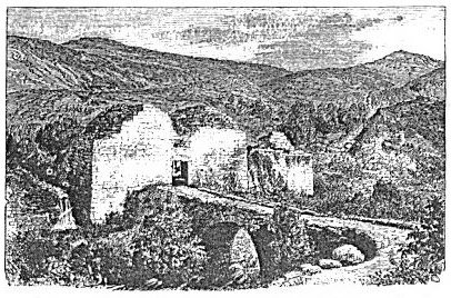 |
| SOUTHERN GATE OF CÆSAREA-PHILIP'PI. |
Testament Cæsarea-Philippi.42 Though mentioned in the Bible only in connection with the profoundly interesting conversation in which Jesus first drew from the twelve a full confession of their faith, it has an interesting history. The earliest mention of it is under the name Pan'ium, in the statement of Josephus that Herod the Great built a temple there in honor of Augustus Cæsar.43 We next find Philip the tetrarch rebuilding "Pan'eas, a city at the fountains of the Jordan," and calling it Cæsarea. The suffix Philippi was added to this latter name to distinguish the town from the older Cæsarea, on the sea-coast of Judah.44 After the destruction of Jerusalem, Titus celebrated his victory at this place by games, in the course of which many Jewish [335] prisoners were thrown to wild beasts, and many were compelled to fight as gladiators and kill one another.45 It played an important part in the wars of the Crusades. Its ancient Greek name, Pan'eas, was restored after the end of the Roman dominion, and has been perpetuated in the Arabic form Ban'ias.
The fortified town was small, and in shape it was nearly a square. It stands 1150 feet above the level of the sea. On the eastern side the surface slopes upward from the wall toward the mountain on whose foot it sits, but a deep fosse cuts off exterior approach on that side, except where it is filled up to make a passway. A portion of the wall and one massive square tower are still standing on that side. On the south side a deep narrow chasm with perpendicular sides of naked rock serves the purpose of a natural moat, and a portion of the wall is preserved on this side. The gate, about midway this wall, stands entire, and is still in use. It leads out upon a massive stone bridge, which spans the chasm just outside of it. This gate and bridge are seen in our cut on page 335. The western and northern walls are prostrate almost to their foundations. Just outside the northeastern angle of the city wall lies the famous spring of Ban'ias, which is one of the three principal sources of the Jordan.46 The stream flows thence along the base of the northern wall, and at the northwest angle it empties into a much deeper ravine coming from the north, and flows in a deep chasm along the western wall. Thus the city was defended on three sides by natural moats outside the walls, and these were approached on ground lower than that within the city. The area within these ruined walls is occupied by a small village built on the ruins of ancient buildings, and chiefly from the broken material of the same. Masses of building-stones lie in great heaps on every side, and at one place a long row of massive arches just visible above the surface supports a garden-wall of rough stone recently built upon it. Many pieces of broken columns are seen in the walls of houses and lying among the ruins. A branch from the stream is led across the western end of the town, and falls in a cascade into the chasm outside the southern wall. It supplies the town and irrigates its little gardens. Immediately north of the town, across the stream, is the only camping-place of travelers. It is a level bench densely shaded by large terebinths, among the finest in all the land. Along the course of the stream, from its source all the way to its junction with the other two to form the [336] Jordan, there is a belt of perennial verdure. Immediately west of the town, across the chasm on that side, scattered columns and other remains of ancient buildings show that the city once extended in that direction. This was perhaps an unwalled suburb of temples and similar structures. The ancient name Pan'eas points to the god Pan as its origin, and the erection of a temple here by Herod in honor of Augustus may have been suggested by a worship of Pan already established. Niches and recesses cut in the face of the perpendicular cliff above the great spring still remain in an almost perfect state of preservation, and one of them has the inscription in Greek letters, Priest of the God Pan.
In our advance toward the north we have now reached the line usually recognized in the Scriptures as the northern limit of the land of Israel. This is seen in the oft-recurring expression "from Dan to Beersheba," used to indicate the entire length of the country. We have come to the base of Mount Hermon, and Robinson, with a good degree of plausibility, conjectures that Ban'ias may be the "Baal-gad under Mount Hermon," which is named in the Scriptures as the northern boundary-line.47 An account of the topography of Palestine not including Mount Hermon and the mountains of Lebanon would appear incomplete, on account of the frequency with which they are mentioned in the Scriptures; but both belong to Syria, not to Palestine, and will be described in Part Third. Our present account, however, would not be complete without a brief description of two other interesting localities, one to the east and the other to the west of Cæsarea-Philippi. To the east, crowning the extreme summit of the mountain on whose foot Ban'ias stands, is the celebrated Castle of Ban'ias, one of the most interesting and best-preserved fortresses in Palestine. It covers the entire summit of the mountain, and is 2300 feet above the sea-level. It is 1150 feet higher than Ban'ias, though not much over a mile distant in an air-line. It can be approached only on the south side, and on this side only by very steep climbing. On the other sides the cliffs are perpendicular, or nearly so. The only gateway is on the southern side near the western end, and is approached by a road cut along the side of the cliff from near the northern end and gradually ascending toward the gate. The gateway itself is well preserved, and shows, by the shape of its massive jambs, each a monolith, that its shutter, instead of swinging on hinges, worked up and down in a groove on either side. The foundations of the wall are well preserved [337] all round the hill-top, but the superstructure is much broken, and the buildings which stood inside are nearly all prostrate. The space inclosed is about 300 yards long from east to west, and about 100 yards wide at each end, but scarcely half that width in the middle. The eastern end is higher than the western, and was separated from it by a wall and a moat, which enabled the garrison to retire thither if the western end were taken by an enemy. Many cisterns dug in the rock, and some very large receptacles under the vast buildings which occupied a portion of the interior, show the great care exercised to provide the garrison with water. The northern wall stands over a precipice more than 600 feet deep, the southern side of a deep and narrow gorge that cuts off this mountain from the spurs of Mount Hermon which rise still higher on the other side of it. This gorge passes westward until it reaches a point just north of Ban'ias, when it turns to the south, passes by the camping-ground mentioned above, and thence passes along the western wall of the city.
The view from the castle walls is magnificent. It includes wild mountain scenery to the north and east, a landscape of plain and hills to the southwest, and to the west the distant mountains of Northern Galilee and Southern Phœnicia, some of them crowned with similar castles.
The locality yet remaining to be described in this section is a beautiful, elevated plain north of Abel and 300 feet above the level of the Plain of Hûleh. It is a smooth basin, five miles long and two wide, surrounded on every side by ridges of gentle slope and slight elevation. Through the middle of it a stream of water meanders, and as it approaches the southern ridge it deepens its bed, and finally cuts its way through the ridge by a remarkably deep and narrow chasm, and flows into the Plain of Hûleh. The stream bears the name Derdar'ah, and the plain that of Merj Iyûn' (the Meadow of I'jon). I'jon was the most northern town of Naphtali, and consequently of all Israel,48 although Dan, being more frequented and better known, was habitually spoken of as such. This little valley is one of the most beautiful and fertile of all in Palestine, but the city or town has entirely disappeared. It projects from the northern shoulder of Naphtali, between the spurs of Mount Hermon and the sloping plains which extend from its western side down into the deep gorge of the Litâ'ny. This river here runs parallel to it, but soon turns westward on its way to the sea. [338]
[LOB 313-338]
|
[Table of Contents] [Previous] [Next] |
J. W. McGarvey Lands of the Bible (1881) |
|
Back to BibleStudyGuide.org. These files are public domain. This electronic edition was downloaded from the Restoration Movement Texts. |